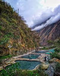
Colcamayo Hike - Huyro to Hot Springs
- Jun 2, 2022
- 2 min read
Updated: Jul 16, 2022
DIRECTIONS
Please download Komoot or maps.me and mark these points before your hike.
The hike is about 16 and a half kilometers and takes about 8.5 hours.
Expierenced hikers that know how to read maps need to be in your group.
Here you start walking on the Inca Trail, it’s a small path in the right of the road.
There should be a women selling stuff, just ask her where to go and then follow the path on the map
Nachsehen
Unbekannter Ort
Meine Orte
ge0://sOPI7Zp7If/Unbekannter_Ort
This is where the road to Santa Theresa starts.
Nachsehen
Hauptstraße
Meine Orte • Hauptstraße • CU-107
http://ge0.me/sOPKRQTTeE/Hauptstraße
ge0://sOPKRQTTeE/Hauptstraße
Continue here going straight, you are still on the Inca Trail
Nachsehen
Unbekannter Ort
Meine Orte
http://ge0.me/wOPI7YVTPv/Unbekannter_Ort
ge0://wOPI7YVTPv/Unbekannter_Ort
Continue here straight, you are still on the Inca Trail
Nachsehen
Unbekannter Ort
Meine Orte
http://ge0.me/wOPI7YVTPv/Unbekannter_Ort
ge0://wOPI7YVTPv/Unbekannter_Ort
Here, the Inca Trail passes through a little village where several paths are, just ask where to follow the Inca Trail or just follow the map. But everybody there knows the way.
You can’t get lost!
Nachsehen
Fußweg
Meine Orte • Fußweg
http://ge0.me/0OPI7STqJU/Fußweg
ge0://0OPI7STqJU/Fußweg
Then you come by this beautiful viewpoint. Still on the Inca Trail.
Aussichtspunkt
Meine Orte • Aussichtspunkt
http://ge0.me/wOPI7RABq8/Aussichtspunkt
ge0://wOPI7RABq8/Aussichtspunkt
And this is where you leave the Inca Trail and get back on the main road for a few minutes
Fußweg
Meine Orte • Fußweg
http://ge0.me/wOPI5xm7FE/Fußweg
ge0://wOPI5xm7FE/Fußweg
You will come by some restaurants where you can eat something and then continue walking 5 minutes to the bridge that you have to cross to get to the other side of the river.
Nachsehen
Yellow River Lodge
Meine Orte • Hotel
http://ge0.me/0OPI5b5-u0/Yellow_River_Lodge
ge0://0OPI5b5-u0/Yellow_River_Lodge
Here you have to go to the left on a small path down to the river.
Nachsehen
Fußweg
Meine Orte • Fußweg
http://ge0.me/wOPI5xMF_L/Fußweg
ge0://wOPI5xMF_L/Fußweg
Cross the bridge here
Unbekannter Ort
Meine Orte
http://ge0.me/0OPI5bRXxc/Unbekannter_Ort
ge0://0OPI5bRXxc/Unbekannter_Ort
Then on the other side you have to walk 45 minutes uphill to get to the street. Only one path but if you are not sure just walk uphill and you won’t miss the road.
Nachsehen
Straße
Meine Orte • Straße
http://ge0.me/wOPI5eBs4q/Straße
ge0://wOPI5eBs4q/Straße
Then follow the street until you get to this point. There are some houses. Ask there where to cross the river again and they will bring you to the “cable car”. Once you are on the other side of the river you are as good as there. Just walk 2 minutes to the entrance of the Cocalmayo.
Nachsehen
Unbekannter Ort
Meine Orte
http://ge0.me/4OPIz9WWOk/Unbekannter_Ort
ge0://4OPIz9WWOk/Unbekannter_Ort
There should be the cable car.
Nachsehen
Unbekannter Ort
Meine Orte
http://ge0.me/4OPIz3-JB_/Unbekannter_Ort
ge0://4OPIz3-JB_/Unbekannter_Ort
Thanks Elena for providing these directions!

%20(1).png)


Comments